
Map Fridley ZIP Code Coverage
Fridley’s two primary postal ZIP Codes are 55432 and 55421. The Anoka County ZIP map places both in the southern county and also shows nearby 55433. Postal geography is useful for validating an address and choosing a first search field. It is not the same as a Fridley city boundary. The coverage below preserves the county map and USPS cautions, including the difference between a main Fridley ZIP and a nearby ZIP that requires address-by-address confirmation.
| ZIP | Areas Covered | Post Office | Notes |
|---|---|---|---|
| 55432 | Main Fridley ZIP; also associated with Spring Lake Park and Minneapolis mailing labels | Fridley Carrier Annex, 385 Northco Drive; Fridley retail location, 7440 University Avenue NE | A Fridley parcel may display Minneapolis as its postal city. Confirm the exact address with USPS. |
| 55421 | Portions of the Fridley area and areas of Columbia Heights, Hilltop, and St. Anthony | Columbia Heights retail location, 940 44th Avenue NE | This ZIP crosses municipal lines and cannot be treated as a Fridley-only result set. |
| 55433 | Nearby Anoka County ZIP shown on the county map | No Fridley service assignment verified in the reviewed sources | Do not assign 55433 to a Fridley address until the specific address is confirmed through USPS. |
The table is intentionally cautious about 55433. The county map supplies nearby context, but it does not establish that any particular Fridley address is served by that ZIP. That small distinction matters before searching a parcel or election tool.
Read Fridley ZIP Postal Cities
USPS identifies the Fridley Carrier Annex at 385 Northco Drive as Minneapolis, MN 55432-3304, even though the facility serves the Fridley ZIP area. It lists call-referral, carrier, and collection hours, but no retail, passport, or financial services. USPS also identifies a Fridley retail location on University Avenue NE with a Minneapolis postal-city label. These names explain why a geographically Fridley address may have Minneapolis in a mailing field.
The USPS Fridley Carrier Annex listing documents the carrier facility and its service scope.
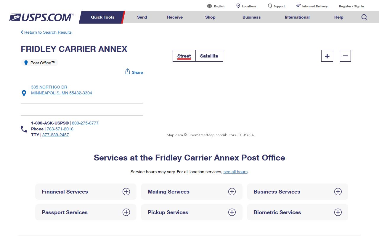
The practical record note has two fields: municipality and postal city. The Anoka parcel card can identify the municipality as Fridley while the USPS display says Minneapolis, MN 55432. Neither field should be overwritten by the other.
Keep Fridley ZIP 55421 Separate
ZIP Code 55421 is a clear boundary example. The research ties it to portions of the Fridley area as well as Columbia Heights, Hilltop, and St. Anthony. A search that begins and ends with 55421 can therefore mix several local governments, parcel systems, and civic geographies. First validate the complete address, then use the county parcel record to determine whether the geographic municipality is Fridley.
ZIP Code 55432 has a different complication: its postal-city display can say Minneapolis for a Fridley location. The two situations look similar in a spreadsheet but mean different things. One is a shared delivery geography across municipalities; the other is a postal label that may differ from the city that governs the parcel. The Fridley ZIP code directory keeps those distinctions visible before any record comparison begins.
Note: A county ZIP map is a boundary guide, while the USPS address lookup is the control for a particular delivery address.
Validate a Fridley ZIP Code First
Use the USPS ZIP Code Lookup for the address-to-ZIP check. Then enter the confirmed address in the Anoka GIS, where address and PIN searches provide the parcel context. The GIS category instructions emphasize address and parcel ID rather than a ZIP-only search, although a parcel card displays ZIP as one result field. This is why ZIP is best used to validate and narrow an address, not as a substitute for it.
- Enter the complete address in USPS ZIP Code Lookup and save the returned ZIP and postal-city display.
- Open the same address in the Anoka County Property Search GIS. Record the PIN, situs address, municipality, ZIP, plat, and owner or mailing fields separately.
- Compare the parcel municipality with the USPS postal city. For a Fridley parcel in 55432, Minneapolis in the postal field can be expected rather than an error.
- Use MNVotes or MyBallotMN only for the limited election question each tool answers. A ZIP search does not return a list of everyone in that ZIP.
- Once the ZIP and parcel are confirmed, use the Fridley street directory for the narrower address-to-owner and recorded-document trail.
Property Access may also be useful for owner, address, or PIN work when it is available, but its live ZIP filter options were not verified because the county portal was under maintenance. Do not assume a ZIP search field that the official live form did not expose.
Use Fridley ZIP Election Fields
MNVotes and MyBallotMN both accept ZIP-related input, but they serve different functions. MNVotes is a nightly-updated registration-status tool. It requires first name, last name, birthday, and address information. MyBallotMN accepts an address or ZIP Code and returns the next election, polling place, ballot, precinct, district information, and caucus locations. Neither tool is a ZIP-based directory of residents.
| Tool and Field | Format or Option | What It Returns or Limits |
|---|---|---|
| MNVotes: first name, last name, birthday | Text and date input | Required identity details for a registration lookup. |
| MNVotes: ZIP Code or county | Address-mode starting field | Begins the street-address path; it does not return all registrants in a ZIP. |
| MNVotes: city or township, house number, street | City or township control, numbers-only house input, street selection or autocomplete | Completes the address comparison. Unit number becomes required when the apartment or unit box is selected. |
| MyBallotMN: address or ZIP Code | Address or ZIP search | Election, polling place, ballot, precinct, district, and caucus information for the election geography. |
The MyBallotMN address search is the official election-geography tool for a validated Fridley address.
Minn. Stat. §201.091 separately controls inspection and copying of voter information. A full date of birth and other sensitive identifiers are not public voter-file fields, and the list cannot be published online in searchable form. Use the statewide tools for their stated election purposes and ask the appropriate custodian about a controlled record request.
Link Fridley ZIPs to Parcels
After USPS validates a Fridley ZIP Code, the parcel map supplies the records geography. Anoka GIS can search by address or PIN and can display current and historical aerials, plats, half sections, mailing labels, measurement, and map-making tools. County downloads include parcel, address, road, ZIP, precinct, polling-place, boundary, school, and other datasets. The county says GIS parcel lines are approximate, so use them for orientation and compare them with the recorded legal description when a boundary matters.
The GIS card may show a ZIP with owner and mailing information, but that does not establish a resident at the site. The county’s sample PIN 24-30-24-41-0259 was in Fridley with ZIP Code 55432 and an association owner, while the situs address was blank. That result is a useful reminder that an address, a postal ZIP, a mailing address, and a parcel owner need not describe the same relationship.
For a deed question after the parcel is known, Anoka County Recorded Document Access and the Room 119 public research terminals provide the grantor, grantee, and legal-description route. Match the legal description rather than assuming a ZIP or street label carries backward through every land transfer.
See Fridley ZIP Code Geography
Fridley’s ZIP pattern is a useful records-geography lesson. The city’s 2020 population is listed as 29,590, but city population is not a ZIP count. Census ZCTAs are statistical approximations, while ZIP Codes are USPS delivery geographies. A ZCTA can support broad statistical context in data.census.gov, but it cannot validate that a particular address receives mail in a particular ZIP or identify a Fridley municipal boundary.
No official historical Fridley ZIP realignment or city-specific street-renumbering schedule was located. The reliable record is more modest: 55432 and 55421 are the primary ZIPs, 55421 crosses multiple municipalities, 55433 needs individual address verification, and USPS may display Minneapolis as the postal city for a Fridley address. The Fridley ZIP code directory is more accurate when it preserves that uncertainty than when it forces every result into a single city label.
Define Fridley ZIP Code Limits
ZIP Code boundaries are delivery boundaries, not city limits. The right path is to validate the exact address with USPS, confirm the municipality and parcel in Anoka GIS, then use election tools or land records only for the question they actually answer. A ZIP can narrow a search, but it cannot prove a household relationship, ownership, or a person’s current location.
- ZIP Code
- A USPS delivery geography used to route mail. It can cross city boundaries.
- ZIP+4
- The added four-digit delivery detail used with a ZIP Code. Validate it from the complete address rather than inferring it from a map.
- Postal-city label
- The city name USPS displays for mailing. In the Fridley area, Minneapolis can be a postal label even when the parcel municipality is Fridley.
- Carrier route
- A postal delivery route. The Fridley Carrier Annex provides carrier service for the 55432 area but is not listed with retail, passport, or financial services.
For public data that is not online, the Anoka County data-request route explains public, private, and confidential classifications under MGDPA. Ask for a precise address, PIN, document type, or date span, and treat a protected or missing field as a limit rather than a lead to defeat.